13 Jan 2012
What it looks like when food grows everywhere
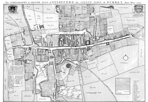
Today I’d like to share a map with you (click on it and it will magically fill your screen), and I’m hugely grateful to Geri Smyth for giving me this. It is a map of the town of Guildford (or Guldeford as it was then) in 1793. Regular readers will know I love a good map, and I have spent a fair while poring over this one. There are a couple of things I love about it. Firstly, it is the most amazing piece of draughtsmanship. It is a thing of extraordinary beauty in a way that Googlemaps can only dream of. The way its laid out, the calligraphy, the attention to detail, are beautiful in a way very few people could recreate today. But what is so extraordinary, upon closer inspection, is how it captures what it looks like when food grows everywhere. Think of it, if you like, as Incredible Edible Guildford, circa. 1739.
This is a Guildford before the car, before before shopping malls, before tarmac. It is also clearly a Guildford with a much lower population than today, with far far lower living standards, and with a lot more mud on the soles of its shoes. My reason for posting this beautiful artifact isn’t to romanticise times that were very different, and in many ways much harder, rather it is to marvel at what a really local food culture looks like in reality for those of us who have no living memory of such a thing.
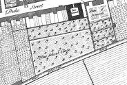
 We see, for example, that the hospital has its own vegetable garden. The Free School has its own orchard. While many of the houses have their own gardens, others appear to have allotments out the back, large pieces of land divided into plots. In the centre of the map is a cluster of coaching inns, each of which have yards full of vegetable gardens. Behind every house, on every piece of ground, food is being grown. It is an extraordinary snapshot of a time when food production was the principal form of urban land use after roads and buildings. I won’t say more about it, just take some time to let your eye wander over its surface. You can download a hi resolution pdf of it here (caution, it’s a big file).
Makes me think how the maps of the future of our settlements will look. Peeling back the tarmac as our priorities change, as the economics of globalisation begin to go into reverse, as our cultural perceptions of the usefulness and attractiveness of lawns start to change, and as the need to create meaningful and fulfilling work grows, will transform our urban terrain. Adding in rooftop growing, vertical growing and other more recent innovations, and we’ll see the places we live transformed.
I walked this morning through the frost, and past my local allotments in the early morning sun, sparkling with frost and with a low mist hanging above it, catching the first rays of the morning sun as it emerged. How much more life-affirming, exhilarating and nurturing such a thing is to experience in everyday life than carparks and lockup garages. Perhaps it’s just me, but a walk of the imagination around the landscape captured in this map is not just a look back into our past, but also, in many ways, a look forward into our future.

Jo Homan
13 Jan 11:41am
that’s really lovely. I notice the use of ‘field’ (grazing?), ‘land’ and ‘garden’ – what was “Sarah White’s land” used for, I wonder. And what is that garden with the spiral maze? I can’t see a big manor house next to it, but it is near Duke Street.
Rob
13 Jan 11:54am
I’m sure there’s a board game in her somewhere, roll a double 6, move down Duke Street and pick up 10 cabbages….
Jennifer Lauruol
13 Jan 12:23pm
In the Netherlands, even in deepest, dense-ist Amsterdam, people grow plants & food right on the street up the front of the buildings. Thanks for posting this Rob, I’ve tweeted it out to the folks 🙂
Ted
13 Jan 5:53pm
My home town of St. Louis, MO published a map in 1875 that captures the city at an interesting time. If you zoom in (site a touch slow, but the resolution is very good) you can see how the city is growing into the agricultural land that surrounded it. You can see where orchands and farm fields were located on the map. Enjoy!
James Samuel
13 Jan 7:17pm
After meandering around through this field and that, through endles gardens and over bridges, I noticed “The Arms of the Corporation”. Is this a sign of the long-assumed system of land ownership and control, of land lords and their tenants, taxed on the fruits of their labour?
Are we beginning to question these arrangements and their legitimacy? Arrangements which turn us into modern-day slaves (even slaves had wages). Are “The Arms of the Corporation” a symbol of an old way that no longer serves, but undermines our ability to live sustainably on this finite planet, and one that is being questioned through movements like Occupy.
Is it time to Occupy the fields and gardens and claim a life-affirming, exhilarating and nurturing life?
Urban gardens and orchards need to make a comeback — Transition Voice
13 Jan 8:07pm
[…] 27 miles southwest of London. Transition Network co-founder Rob Hopkins recently unearthed an 18th-century map of the town showing how yesteryear’s version of smart development revolved around maximizing […]
Gavinthornbury
13 Jan 11:05pm
Each English market town was usually established one day’s walking distance apart, about 20 kilometres due to poor roads, and have a local monopoly of buying or selling goods. That is to say, it would be at the centre of an area of very, very approximately 100 square kilometres.
Assuming a pre-industrial agriculture population density of 2 to 3 people per hectare of arable land growing wheat, re David Pimentel, then each square kilometre could support around 250 people. And so 100 square kilometres could support very roughly 25,000 people. We know that pre-industrial farming could produce a sufficient surplus large enough to permit a non-rural population of 20%, which would be perhaps 5,000 people. Fairly arbitrarily, we could then assume that population distribution follows a power law, with 50% in villages and the other 50% living on the market town.
About 2,500 people.
By coincidence, the 1950 poulation of Thornbury was around 2,500. And the population of the next nearest market town, Berkeley at 14 kms away, was also 2,500.
Gustoso
14 Jan 8:36am
Oh wow. We used to live in Guildford. I love the huge big park just past the railway line.
Howard
14 Jan 2:07pm
This really is quite inspiring. What would it look like if today’s barren, fields of grazing cattle and sheep were transformed into individual or community growing areas? Wait for it … PEOPLE might actually be seen in the countryside again, growing their own food and trading surplus with each other. One day, maybe.
Chris
14 Jan 5:24pm
I love a good map. Maps tell stories, and good maps tell good stories. This is a great map.
What we now need are people drawing maps like this for communities that have not been built.
Working in permit review I tend to see developments that favor over-sized home products crammed onto postage stamp lots. The reality is that after the average citizen takes over the property from the developer they almost instantly begin complaining that they don’t have enough room for patios, decks and sheds. Compounding the poor choice of incompatible home and lot size is little or no thought given to orientation in relation to the sun or topography. So on one side of the street all of the houses have driveways that never thaw in winter and remain sheets of ice and on the other side of the street the rear yards stay snow and ice covered year round and get little direct sunlight light during the growing season.
The conventional thinking in the development world is to maximize profit at the expense of all else.
Michel
18 Jan 1:13am
@Jennifer
Even though that is true, it is not so wide spread as I would like. I am actually involved in a project to start a community garden in Amsterdam New West. Some city districts and some housing corporations have interest in funding it.
David
19 Jan 12:00am
Rob, have you heard of this new thing called ‘free food’? Apparently, if you just draw the outline of a carrot in the soil and cover it over, in the morning it turns into a lovely bunch of carrots! There’s a cover up by the supermarkets but I’ve heard that those butter mountains in the EU were an accident created by a farmer with too much free time on his hands. Just google it – everything I say is true!
andrew ramponi
19 Jan 10:20am
Lovely map, even more so for those familiar with the town today I expect.
I wonder what the Cook Pit was used for, and why was there a Rats Gate? Also interesting that the Old Bowling Green was turned into food growing beds, and there is elsewhere a Bowling Green and Bowling Green Field.
All I ask is for a good map and glasses to read her by…
Amanda
20 Jan 4:15pm
It would be interesting to do a projection of the same map if all available growing areas, walls, floors, roofs and station platforms were planted!